
As a partner in a Draper software company, I enjoy researching and solving problems. With my wife’s recent campaign for state house, as of late I have found public policy issues to be especially intriguing. Given the data-intensive nature of the recent redistricting efforts, I found myself unable to resist trying my hand at drawing a map of my own.
The first thing to jump out at me was the seemingly unintuitive nature of the boundaries for the original maps proposed by the committee. None of the maps to me felt elegant or stylistically appealing. Take Plan “A”, for example. This is the original map drawn up by the 2001 redistricting committee. The districts converge unnaturally within just a few miles of each other and the northern Salt Lake County “fjord” seemed unintuitive.

Non-compelling convergence of districts in Plan “A”
 Plan “J” – No clear community of interest in the new 4th District
 “Rough-cut” division of Salt Lake County
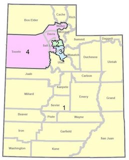
Plan “G” (the plan originally drawn up by the Democratic members of the committee) didn’t seem right, either. Having organized canvassing routes for my wife’s small house district campaign, I was blown away at the sheer size of plan “G”’s proposed rural 1st district; I had pity for any candidate in such a district looking to connect with his or her voters. Additionally, the population centers of Logan and St. George also didn’t appear to have much in common. Also, as with plan A, Salt Lake County was partitioned into 3 separate districts. Given these reservations, though, I thought that the general concept of an “Oquirrh 4th” district made sense for two reasons; 1st, in my view, western Salt Lake County has been split for too long into separate congressional districts, and; 2nd, this region has unique and substantive transportation needs. It made sense to me for this area to have a representative focused on those unique needs.

Plan “G” with its burgeoning rural 1st district
Plans I and J also held limited appeal. If you look at the boundaries for the new 4th district there is no clear “community of interest” being represented. Additionally, the boundary between the northern and southern portions of Salt Lake County crossed various city lines and there was no use of any “landmark” boundaries, such as the Jordan River or I-15. Also, the addition of Morgan County in the 2nd district seemed to be a token gesture designed to reverse-engineer the district into a rural-urban hybrid. Based on the 2000 census, the entire county housed only 7,129 residents, or 0.32% of the total population. The actual rural representation, then, would have been extremely limited. Given this, it made sense to me for Morgan to be included with its northern neighbors, Weber and Rich counties.
 Plan “J” – No clear community of interest in the new 4th District
After reviewing all of the maps, none of them seemed to have the soundness, elegance and intuitive “good feel” I thought they should. So, I set about creating a new “proof of concept” (engineering lingo for a “pre-plan”). First, I thought through some initial “key design considerations,” which included the following:
- By statute, provide an equal population in each district (558,292) based on the 2000 census. One of the four districts would have 558,293 individuals (the remainder after division).
- Protect incumbency (as recommended by Congressional leaders)
- Split Salt Lake County into no more than two districts (the Governor expressed this desire)
- Minimize splitting of other counties
- Provide high-growth areas in each district
- Avoid unusual partitioning (jut-outs, wraparounds, islands, etc.)
- Unify districts around common interests.
Any successful plan that I would work on would have to satisfy these considerations. I researched previous committee minutes for other possible considerations. It seemed a bit odd to me that I could not find a “top-down” list of standards from which the committee would draw up their plans. Perhaps there was such a list but I was unable to find it.
Since Salt Lake County could only be split into two segments, it was obvious that an entire district could be crafted entirely from one segment of the County. Since I had already planned to include an “Oquirrh District” similar to Plan “G” for the reasons stated above, the dividing line for the 2nd district would then run north-south. I should note that drawing the exact line at the census block level was out of scope for such a “proof of concept.” Nevertheless, the sheer number of residents along the Wasatch front makes such an effort entirely possible with a little work.
Since Salt Lake County could only be split into two segments, it was obvious that an entire district could be crafted entirely from one segment of the County. Since I had already planned to include an “Oquirrh District” similar to Plan “G” for the reasons stated above, the dividing line for the 2nd district would then run north-south. I should note that drawing the exact line at the census block level was out of scope for such a “proof of concept.” Nevertheless, the sheer number of residents along the Wasatch front makes such an effort entirely possible with a little work.
 “Rough-cut” division of Salt Lake County
Now, moving to the new “Oquirrh 4th,” since I believed the community of interest should center around transportation and growth needs, it made intuitive sense to include portions of western Davis and western Utah counties. Fortunately, our current congressional districts already divide those two counties, so it wasn’t a stretch to me for them to remain divided. To make the districts equal, I included 105,928 voters from western Davis county and 71,535 voters from western Utah county. Roughly, the population centers west of I-15 for both districts can be used, forming a landmark boundary that makes such a division more intuitive. Since there was no compelling reason to split Tooele county, I included it in its entirety in the new 4th district. Again, since this is a proof of concept, drawing the exact boundaries at the census block level would require some additional effort, though segmenting on the larger counties will make such an effort much more straightforward since smaller shifts in the boundaries would encompass many more residents.
 Roughing-up the new 4th “Oquirrh district”
This left me with completing the 1st and 3rd districts. With the huge percentage of BLM land south of Point of the Mountain, it made intuitive sense to me to make the 3rd district a “south district.” This left the 1st district as a contiguous and sensible “northern district.”
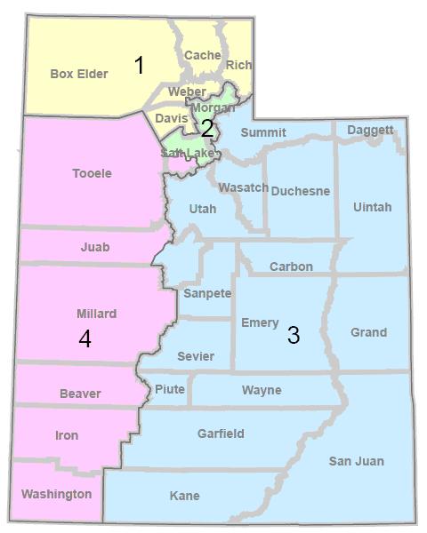
So, without any further ado, here is the completed proof of concept map!!!
So, without any further ado, here is the completed proof of concept map!!!
 Completed Proof of Concept Map
So there you have it! Is this a perfect map? Probably not. Based on recent feedback, portions of Summit county may be better served in the 2nd district, with the difference being made up in the 4th. Perhaps the portion being borrowed in Utah county could be adjusted (an early draft had the smaller Utah county segment coming from the east side and going into the 1st district, for example). The potential to tweak the map goes on and on. However, I do think that the map meets the stated design considerations and has a good feel about it.
I must admit that this was much harder than I originally thought. It took hours to get this map drawn up with the populations equaling out. My hat goes off to the committee for crafting so many different plans. I truly have a greater appreciation for the challenges they faced. Given the design considerations listed above, though, I believe there is a strong defensible case for a proof of concept such as the one presented here.
I believed enough in this map to present it to the redistricting committee on Tuesday. I wasn’t sure what to expect. I was quite pleasantly surprised, though, that it turned out to be a very positive experience speaking before the committee. And although my wife’s erstwhile opponent sits on the committee, such an occurrence didn’t seem to matter much (it didn’t to me and I hope it didn’t to Rep. Hughes). I appreciated the many questions posed by the committee members. There was also a good feel about the committee – it didn’t seem to have the same partisan rancor that I’ve witnessed in other situations.
Independent of the debate on who should draw up these boundaries, I firmly believe that a research-based approach to redistricting is in our state’s best interest. Personally, I would like to see a clearer, publically available definition of the standards used in drawing up future proposals along with clearly presented evidence showing how each proposal meets such standards. I personally think the debate should begin with the drafting of such standards, proceeding then to the creation of the proposals themselves. From my perspective, setting a goal to create a comprehensive evaluation rubric accounting for such standards would be a great step forward.
I’d love to hear your comments and feedback.
Kind Regards,
Craig Johnson
Draper, Utah
craig@metaserve.org
1 comment:
Looks as though "Plan L From Outer Space" won the day.
I wonder if, after losing Tooele, Morgan, and Summit Counties, the new demographics in the first district will permit the congressional race in '08 to be at least somewhat of a contest.
Yeah, right.
Post a Comment